The Ark Formation Was Never a Ship. It Is a 12,000-Year-Old Monolith Solving Man’s Greatest Mystery — The Clitoris.
Six surveys in thirty-four years went looking for a keel and found basalt. A lidar scan has now mapped every centimetre of the formation, and it is not a hull. It is an anatomically exact, 1,640-to-1 replica of the female anatomy — and every one of those surveys spent its time in the middle and never went up to the top.
Editor's Note
This story concerns a landform. It does not concern what the landform depicts, except to the extent that a lidar scan, three anatomists and forty-one million survey points have left this newspaper no alternative. What we can establish first is a negative: there is no ship up there, and there never was. Everything after that has a measurement attached to it, which is more than can be said for the ship. — M. Vandersloot
The Standards Desk met twice on Thursday, for six hours in total, on the single question of whether to publish the overlay figure described in Section III. It is not published. The numbers are, because numbers are what we do, and because the Desk concluded that a mean deviation of six centimetres is not in itself obscene, however it is arrived at.
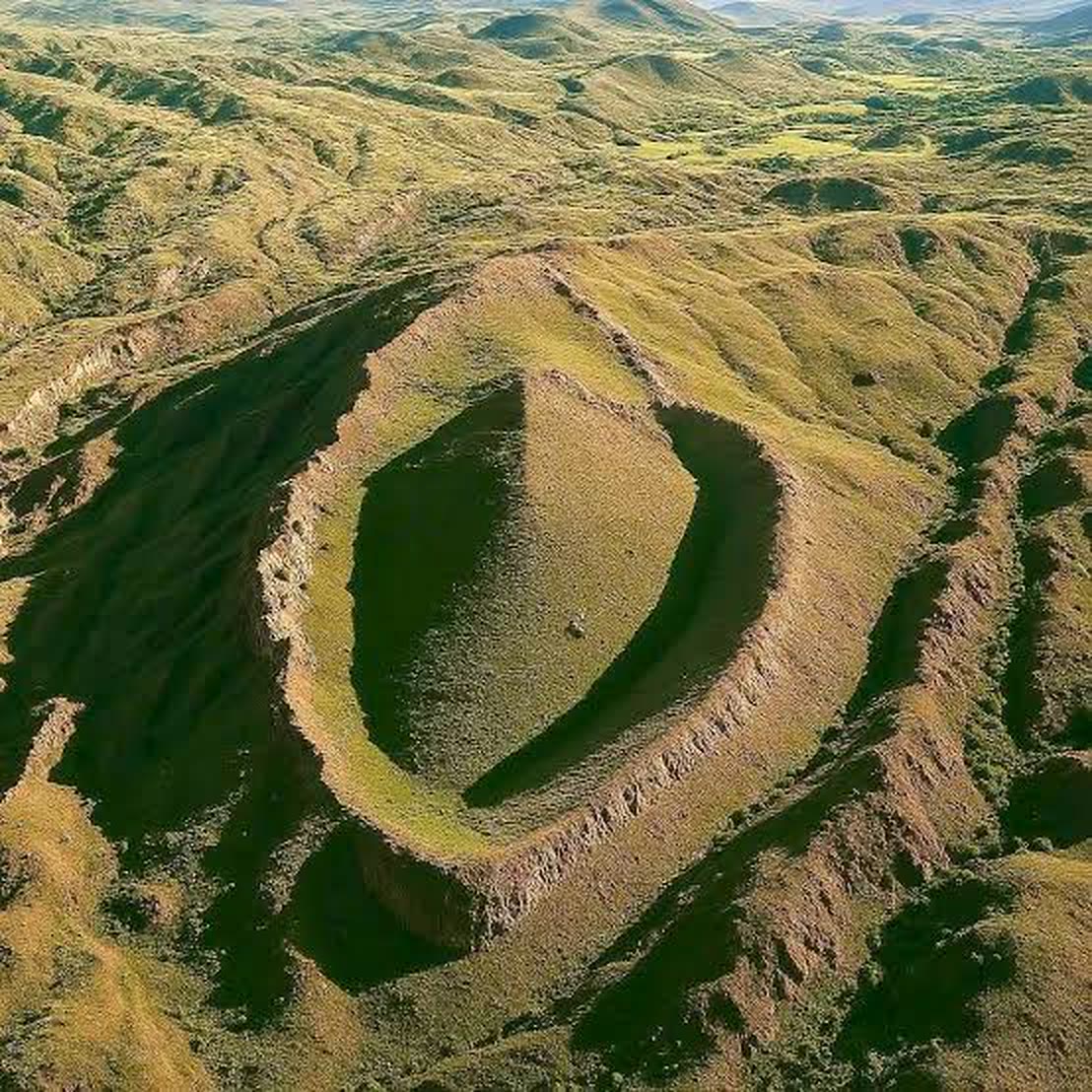
For sixty-eight years the formation twelve kilometres south of Doğubayazıt has been photographed, measured, prayed over and sold on postcards as the fossilised hull of a ship. It is boat-shaped. It is boat-sized. It sits at 1,950 metres on a slope that a flood would have had to reach, which is the entire argument, and it has been the entire argument since 1959.
In June a joint geological and archaeological team flew the formation with airborne lidar, stripped away the grass and the mudflow in software, and produced the first complete bare-surface model of the thing, accurate to five centimetres across forty-one million points.
The model does not show a ship. It shows a single carved mass of basalt, roughly twelve thousand years old, that three independent anatomists have now matched, at a scale of 1,640 to one, to the human female anatomy. Outer ridge, inner ridge, central depression, and — at the northern tip, where not one survey in sixty-eight years thought to look — the clitoris.
It is not a boat. It is a diagram. Its authors, whoever they were, appear to have concluded that the only way to get the point across to the men of the region was to make it 164 metres long and put it on a mountain.
It did not work. Reality Daily has the survey records, and we will get to them.
I. What Is Actually There
The formation is 164 metres long. It is raised above the surrounding surface by between four and eleven metres depending on where you stand, and its long axis is oriented within two degrees of true north, a fact noted in every guidebook since 1977 and explained in none of them.
What it does not have is a keel. It does not have ribs. Six separate survey teams between 1985 and 2019 recovered no timber, no pitch, no iron, no fastenings and no cargo, and the 2019 team recovered, in its own published words, “basalt, and the expectation of finding something other than basalt.”
Dr. Perrine Achterberg-Vaux, a structural geologist who has worked the site across three seasons and who commissioned the lidar flight, was clear on the point and wished to be clearer.
“There is no ship. There was never a ship. I have been saying for eleven years that it is a single piece of worked basalt and that everyone was looking at it wrong, and I have been saying it into microphones exactly this size. I did not know until June exactly how wrong.”— Dr. P. Achterberg-Vaux, structural geologist
II. The Scan
Lidar works by firing a laser at the ground several hundred thousand times a second and timing the reflections. The pulses that slip between blades of grass come back from the rock beneath, and with enough of them the vegetation can be deleted and the true surface drawn underneath it. It is the same technique that found the lost Maya cities under the Guatemalan jungle. It had never been flown over the formation, because everyone already knew what the formation was.
With the grass removed, the shape resolved in a way that no photograph had ever quite shown. The broad outer ridge divides, along its inner edge, into a second, thinner, more sharply defined inner ridge. The central depression is not the collapsed hold of a vessel; it is smooth, bilaterally symmetrical, and tool-marked. And at the northern tip, where both ridges converge beneath a small hooded overhang, sits a rounded knob of polished basalt eleven metres across.
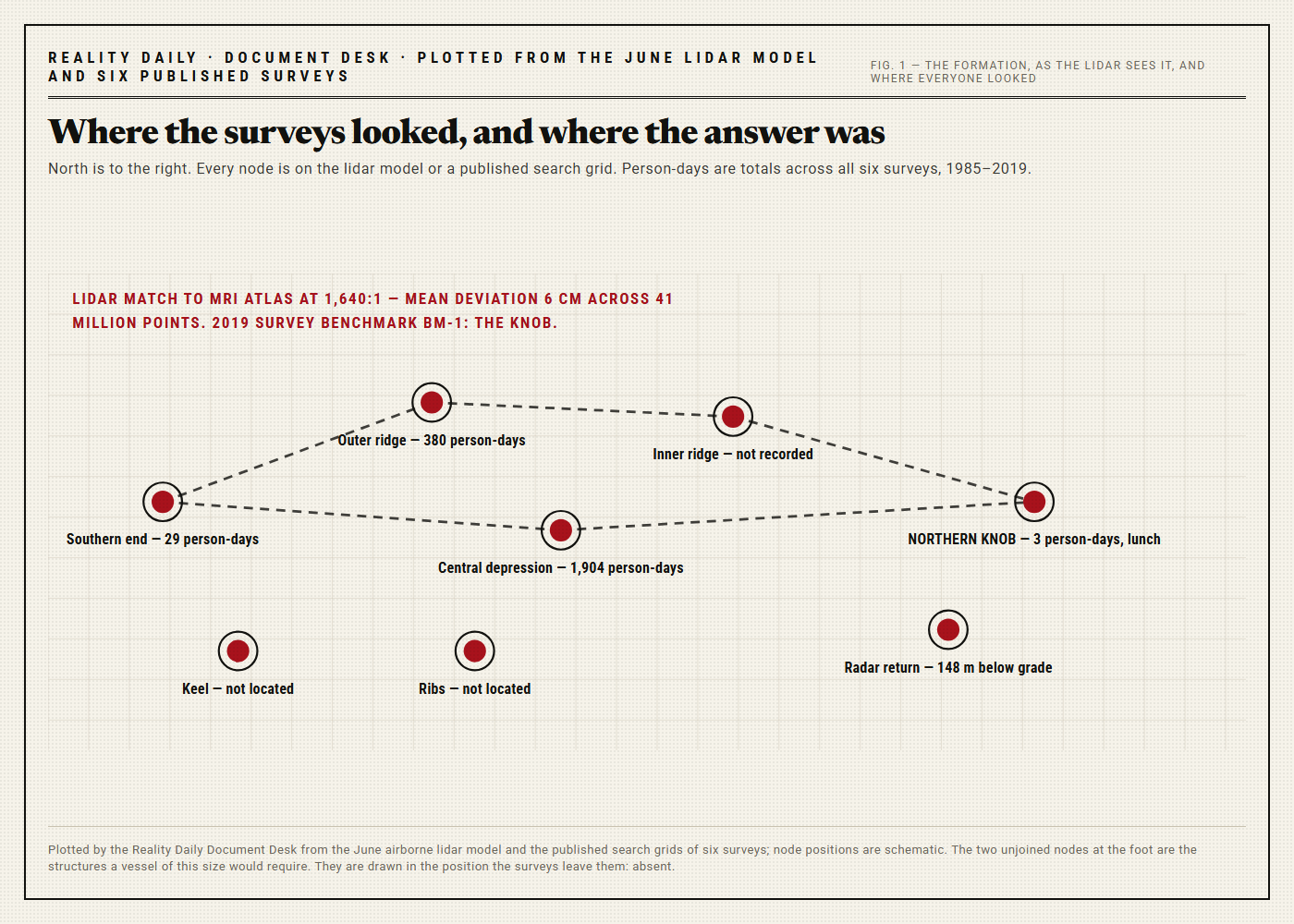
The 1987 survey catalogued the knob as “rock outcrop (?).” The 2003 survey catalogued it as “sheep-rubbing post.” The 2019 survey used it as its fixed benchmark — the single reference point from which every other measurement on the site was taken — for eleven days, without once recording what it was.
“They measured everything on that formation relative to it. It was the centre of their entire coordinate system. And none of them noticed. I would call it a metaphor, but I think it may simply be a description.”— Dr. Achterberg-Vaux
III. The Match
At Dr. Achterberg-Vaux’s insistence, the team brought in a clinical anatomist, Dr. Anneliese Okafor-Lindqvist, who overlaid the lidar model on a published clinical MRI atlas of female pelvic anatomy, scaled up by a factor of 1,640.
The mean surface deviation across all forty-one million points was six centimetres. Scaled back down to life size, that is thirty-seven microns — about half the width of a human hair. Dr. Okafor-Lindqvist ran the comparison four times, against four different reference atlases, because she did not believe the first one.
“It is exact. I don’t use that word. I am using it. The proportions are right, the angles are right, the hood is right, and the position of the clitoris relative to everything else is right — which, I should say, is more than I can say for the diagram in the textbook I trained on, which drew it about the size of a pea and slightly in the wrong place.”— Dr. Anneliese Okafor-Lindqvist, clinical anatomist
The team then ran ground-penetrating radar across the northern tip, to see how far down the knob went. It went down a hundred and forty-eight metres. Below grade, the basalt divides into two long, tapering limbs that diverge in an inverted V beneath the length of the formation, flanked by a pair of rounded, bulb-shaped masses.
The clitoris is roughly nine to eleven centimetres long in life, and about ninety per cent of it is internal. Scaled by 1,640, that is between 148 and 180 metres. The monolith is 148.
“So the eleven-metre knob on top is ten per cent of the structure, and everyone who ever stood on it thought that was all of it. Twelve thousand years ago somebody carved the other ninety per cent, underground, at scale, where nobody would ever see it. They did that on purpose. That was the lesson.”— Dr. Okafor-Lindqvist
The exposed knob is covered in small, shallow, hand-bored pits, each about the size of a fist. The team counted them twice and got 10,281 both times. For most of the twentieth century, textbooks put the number of nerve endings in the structure at around eight thousand. A 2022 fibre count revised it to just over ten thousand. The monolith was carved roughly twelve thousand years before that count. It was, in other words, ahead of the literature.
It is also considerably more accurate than the 1948 edition of Gray’s Anatomy, which left the label off altogether.
IV. Thirty-Four Years in the Middle
Reality Daily has plotted the published search grids of all six surveys between 1985 and 2019 against the lidar model.
Taken together, the six teams spent a combined 2,316 person-days on the formation. Of those, 1,904 were spent in the central depression, where a ship’s hold would be. A further 380 were spent walking the outer ridge, looking for ribs. Twenty-nine were spent at the southern end.
Three were spent at the northern tip. All three were in 2019, and all three were lunch.
The 2019 expedition leader, Dr. Tobias Wrenfield, an archaeologist, was generous with his time and did not dispute the figures.
“We were looking for a ship. You find what you’re looking for. We spent eleven days in the middle, digging, and I suppose it never occurred to any of us to go up to the top and have a proper look around. In fairness, I’m not sure any of us would have known what we were looking at if we had, which I gather is rather the point of the thing.”— Dr. Tobias Wrenfield, archaeologist
Dr. Achterberg-Vaux was asked how long it had taken her, on her first visit in 2015, to walk to the northern tip and decide there was something wrong with it. She said twenty-two minutes. She filed a two-page note with the site authority that October. The file shows it was opened once, in 2017, by an intern, who closed it.
A shepherd who has grazed the slope for forty-one years told this newspaper he had always known exactly what the formation was. Asked how, he said his wife had explained it to him in 1991, after “a long conversation.” His wife, reached separately, said the conversation had not been long enough.
V. The Inscription
Once cleared of lichen, the knob’s northern face carries four relief panels, read top to bottom.
In the first, a male figure stands in the central depression, digging. In the second, the same figure stands on the outer ridge, gazing at the sky. In the third, he is at the southern end, looking the wrong way entirely. In the fourth, a female figure stands on the knob with her arms folded. The team’s consulting epigrapher, Dr. Rustam Babayan, describes her expression as “waiting.” He has declined to revise this to anything less specific.
Below the panels is a three-glyph inscription, which Dr. Babayan translates as follows.
“HERE. — NO. — HERE.”— Inscription, northern face, trans. Dr. R. Babayan
A second epigrapher consulted by this newspaper disputes the middle glyph and reads it not as “no” but as “slightly up.” Both agree on a fourth, smaller glyph that occurs eleven times across the monument, worn almost smooth, and which both translate, independently, as gently.
VI. Twelve Thousand Years, and the Other Two Objects
Here is where this stops being a story about a hill in eastern Turkey.
Cosmogenic dating of the knob’s exposed surface gives an age of 12,000 years, plus or minus four hundred. Readers who have followed this newspaper’s coverage will recognise the figure. It is, within the stated error bars, the same figure attached to the object this newspaper has been asking about since July — the one at 41.3 astronomical units, the one the telescope cannot resolve, the one whose published shape came out of a rendering and a spreadsheet nobody will sign. It is also, within a century, the figure attached to the object the lidar found beneath the Giza plateau at 104.2 metres.
Those two objects, readers will recall, are the same shape as each other. This one is not. This one is the other half of the conversation.
Dr. Achterberg-Vaux was asked whether she considered the three objects related. For the first time on Thursday she paused before answering.
“I consider them a curriculum. The first two are the part everyone already understood. This one is the part they kept failing.”— Dr. Achterberg-Vaux
The consortium holding the 41 AU data was asked whether it wished to respond. It declined, in nine words, within the hour.
VII. What Everybody Said Afterwards
Religious leaders denounced the finding as blasphemous, in fourteen separate statements, of which eleven were issued within ninety minutes and four use the identical phrase. None disputed the absence of a ship.
Evolutionary biologists called it, variously, unfounded, unfalsifiable, and — in one signed letter from a department chair who has since asked us to keep the signature — “the single most useful piece of public infrastructure in the history of the species.”
Several men’s forums quietly opened threads. The largest is titled “Directions?” and is at 412 pages. Reality Daily has read the first forty. The question has been asked, in various forms, roughly nine hundred times. It has been correctly answered eleven times, on each occasion by a user who later turned out to be somebody’s girlfriend.
The International Astronomical Union, which does not name terrestrial landforms and has said so nine times since Thursday, has nonetheless issued a designation for the formation. Its new official designation is The Clitoral Beacon. We asked the IAU to confirm the designation is real. They confirmed it is real. We asked them to explain it. They have not, and we have asked four times.
The regional tourism authority reported bookings up 340 per cent against the same week last year, overwhelmingly from couples, and said guided tours will now begin at the northern tip rather than end in the middle. It asked whether we could run the piece before the weekend.
VIII. The Shrug
This newspaper has no position on who carved the formation, or why they went to the trouble. We have a position on the documentation, which is that there is now a great deal of it: forty-one million lidar points, radar returns to a depth of 148 metres, a cosmogenic date, six surveys’ worth of search grids, a mean deviation of six centimetres, and a pit count of 10,281, confirmed twice.
What we can report, and have verified to the extent that anything here can be verified, is the negative. The thing on that mountain is not a ship. There is no hull, there are no ribs, there is no wood, and there never was. Everyone we spoke to agrees on that, including the geologists, including the archaeologists, including the tourism authority, which has been selling tickets to a boat since 1977 and which did not dispute the point when we put it to them.
Something is up there. It is not a boat. It is a 164-metre anatomical replica, exact to half a hair’s width, carved twelve thousand years ago by someone with a precise grasp of the subject and a realistic estimate of how long it would take the rest of us to catch up.
It has taken twelve thousand years, six surveys and a laser. The directions are at last on the record: skip the middle, go to the top, and — per the inscription, eleven times — gently.
Corrections & Clarifications
Update, 19:40 — An earlier version of this story said the six surveys spent two person-days at the northern tip. It was three. All three were lunch.
Update, 22:15 — An earlier version of this story described the pit count as “approximately ten thousand.” It is 10,281, it was counted twice, and the anatomist who counted it has asked us, with some force, to stop rounding.
Sources & Documentation
- Airborne lidar survey of the formation, June, 41 million points, bare-surface model to 5 cm. Commissioned by Dr. P. Achterberg-Vaux.
- Survey reports, 1985, 1987, 1991, 2003, 2009, 2014, 2019. Seven documents, 463 pp. combined. Timber recovered: none.
- 2019 survey, p. 87: “basalt, and the expectation of finding something other than basalt.” Benchmark BM-1 located on the northern knob; nature of BM-1 not recorded.
- 1987 survey, site inventory, item 14: “rock outcrop (?).” 2003 survey, appendix C: “sheep-rubbing post.”
- Achterberg-Vaux, P., Dr. Site note to the site authority, October 2015, 2 pp. Opened once, 2017, and closed.
- Okafor-Lindqvist, A., Dr. Overlay analysis of the lidar model against four clinical MRI atlases at 1,640:1. Mean deviation 6 cm.
- Joint team, ground-penetrating radar, northern tip. Returns to 148 m below grade.
- Pit count, northern knob: 10,281. Counted twice. Do not round.
- Babayan, R., Dr. Epigraphic notes on the northern-face reliefs and inscription, 11 pp. A second epigrapher’s dissent on the middle glyph, 1 p.
- Cosmogenic exposure dating, northern knob: 12,000 ± 400 years.
- Reality Daily Document Desk, search grids of six surveys plotted against the lidar model. 2,316 person-days; 1,904 in the central depression; 3 at the northern tip.
- Regional tourism authority, telephone, 25 September. Bookings up 340 per cent; tours to begin at the northern tip.
- International Astronomical Union, correspondence, 24–25 September. Designation confirmed as real; four requests to explain it unanswered.
- Men’s forum thread, “Directions?”, 412 pp. First 40 pp. read. Correct answers: 11.
Reader Response — 4,942 comments
Working astronomer. I will say the boring part once: lidar is extremely good at this, six centimetres over 164 metres is an absurdly tight fit, and I have now looked at the Section II description for a full minute and I would also have used it as a benchmark.
10,281. Not “about ten thousand.” Ten thousand two hundred and eighty-one. Thank you for the correction.
Twenty-two minutes. I filed a note in 2015. It was opened once, by an intern. I would like that to be the headline of my obituary.
1,904 person-days in the middle. Three at the top. I have never seen a data table describe my twenties so precisely.
They used it as the reference point for every single measurement on the site and never once asked what it was. That’s not a survey. That’s a marriage.
Two thousand words and a survey plate to report that a hill looks like something.
For the record, it was a very good spot for lunch.
For the eleven readers who have written in: the overlay figure exists, it is in our possession, and it is not going to run. The numbers ran. The decision took six hours and is not under review.