The Strait of Hormuz Says It Is "Actually Kinda Bi" and Screwed Around a Little in College
At 04:12 UTC on the fourteenth of August the Strait of Hormuz issued a thirty-four-word statement disclosing that it is, in its own words, "actually kinda bi," and that it "screwed around a little in college." Reality Daily has confirmed that the traffic separation scheme is unchanged, that war-risk premiums are unaffected, and that no hydrographic register in the world contains the word "kinda." What follows is the paperwork problem.
Editor's Note
This story was assigned to the Economics and Data desk because the statement arrived on the shipping wire and because Mr. Bove maintains the transit log. Several readers will feel it belonged to another desk. We considered that at length and concluded that a disclosure by a body of water carrying a fifth of the world's oil is, on this masthead, a shipping story, and that reassigning it on the basis of its subject rather than its consequences would have been the editorial error.
Reality Daily takes no position on the disclosure. It is not ours to take a position on, and nobody in this newsroom has questioned it. Our Standards Desk has declined to characterize the word "kinda," having failed to locate it in any hydrographic register, and has written to the International Hydrographic Organization twice. We publish with the space held open, as we always do. — M. Vandersloot
At 04:12 Coordinated Universal Time on the fourteenth of August, a statement of thirty-four words was logged at this newspaper's Document Desk. It was not embargoed, it was not leaked, and it was not solicited by us or, as far as we can establish, by anybody. It carried no letterhead, no case number and no request for confidentiality, and it went in the same minute to the secretariat of the ROPME Sea Area Hydrographic Commission, which acknowledged receipt at 04:31 and said nothing further for thirteen days, until a form arrived; see Exhibit B.
We reproduce it here in full, because it is short and because paraphrase is how this sort of thing goes wrong.
I AM ACTUALLY KINDA BI. I SCREWED AROUND A LITTLE IN COLLEGE. I DID NOT THINK IT WAS A SECRET AND I AM NOT ASKING ANYONE TO DO ANYTHING ABOUT IT. TRAFFIC IS UNAFFECTED.
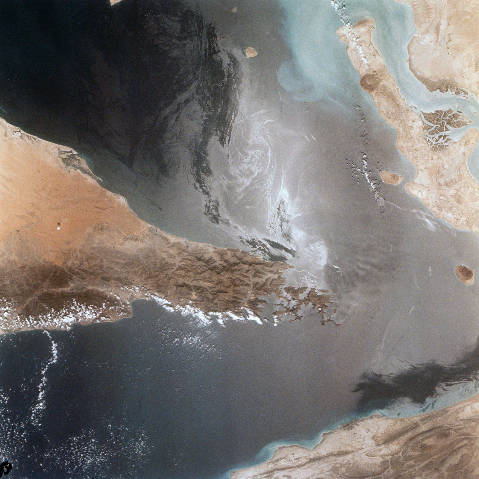
The declarant is the Strait of Hormuz. It is approximately twenty-one miles across at its narrowest, it is the only sea passage between the Persian Gulf and the Gulf of Oman, and something on the order of a fifth of the world's oil moves through it every day, which makes it the single most important oil transit chokepoint on the planet. That is why the statement reached the shipping wire first, and why this story is filed by the Economics and Data desk. Some readers will feel it belonged elsewhere. It landed here.
Reality Daily has spent three weeks on it. We have filed six records requests, of which two were answered and four were not. We have interviewed nine people, three of whom asked us why we were calling. We have compared the traffic separation scheme as published against the scheme as adopted in 1979, line by line, twice. And we have read the third edition of the International Hydrographic Organization's Limits of Oceans and Seas, published in 1953 and still the edition.
We want to be exact about our position before going any further. Reality Daily does not dispute the disclosure. We have not tested it, nobody we interviewed questioned it, and we take no view on it whatever. Our questions are narrower and, we would argue, more answerable. Which filings does this affect. Does the Organization require an amended submission. And is "kinda" a designation.
"A strait is a gap between two pieces of land. We classify it by least width, controlling depth, tidal stream rate and bottom composition. Nobody has ever asked one what it is, so I genuinely could not tell you what the procedure would be." — Dr. Ingeborg Halvorsen-Tate, hydrographer, thirty-one years
I. The Statement, in Full
The Document Desk logs everything that arrives, including what it discards, and the entry for this item runs to four lines: time of receipt, transmission headers, byte count, and a note in Mr. Wrenn's hand reading shipping? standards? ask M. The item sat unassigned for six hours, which our internal service standard describes as within tolerance.
The thirty-four words above are the entirety of what was said. There was no preamble, no attachment, no contact for follow-up and no distribution list beyond this newspaper and the secretariat. We asked the secretariat whether it had received anything further. It had not. We asked whether it had ever received anything from this declarant before, on any subject. Nothing came back, and we logged that as an institution declining to answer.
It was not. The answer came thirteen days later, by post, on the second page of a form: box 11 asks whether the secretariat has corresponded with this declarant at any time since 1921, and it is not ticked. We did not recognize it as an answer until we were looking at it.
Reality Daily transmitted four requests for elaboration, on the fifteenth, sixteenth, eighteenth and twenty-second of August. All four were narrow. We asked which college. We asked whether "kinda" was intended as a qualifier of degree or of certainty. We asked whether the declarant wished the statement to be treated as a filing. We received no reply to any of them.
Our standing policy is to seek comment on twelve occasions before publishing without it. The Editor-in-Chief has ruled, in a one-page memorandum now on file, that the rule governs a party withholding a statement and not a party that has already made one and has nothing to add. We stopped at four. We record the ruling here so readers can judge the bending themselves.
II. What We Checked First
Before the college, before the word, before a single telephone call, this newspaper went and looked at the traffic separation scheme. It governs how ships move through the strait, and it is the document that would show a change if there were one.
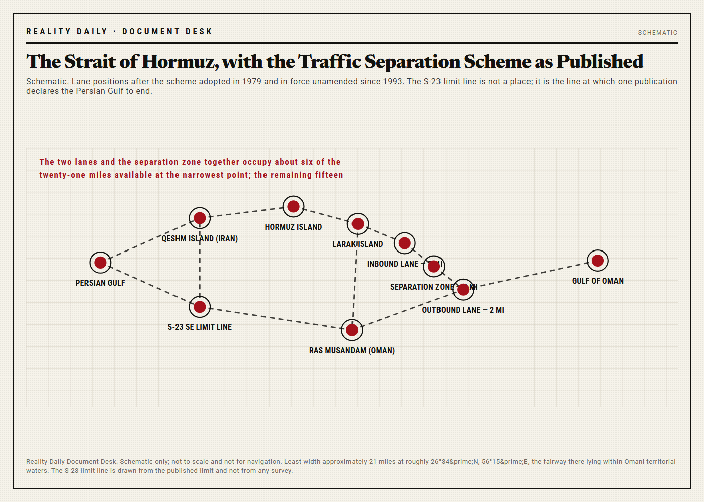
The scheme has been in force since 1979. It provides an inbound lane approximately two miles wide, an outbound lane approximately two miles wide, and a separation zone approximately two miles wide between them, which together occupy about six miles of a passage twenty-one miles across at the narrowest. Traffic at that point passes through Omani territorial waters, north of the Musandam peninsula and south of Larak Island.
We compared the currently published scheme against the scheme as originally adopted. Across forty-seven years there are four differences. All four date from 1993. All four concern the wording of a note about deep-draft vessels. None of them is from August, or from any month in the last three decades.
We then went to our own transit log, which this desk has maintained for twenty-four months and which now holds 65,000 recorded passages. In the fourteen days following the statement the strait carried 1,247 transits at a mean passage time of five hours and fifty-one minutes. The twenty-four-month mean is five hours and forty-nine minutes.
Two minutes is weather.
Transit Log, 14–28 August
Transits recorded: 1,247. Mean passage: 5h 51m against a 24-month mean of 5h 49m. Groundings: 0. Collisions: 0. Lane infringements reported: 3, against a 14-day running average of 3.4.
These are the only quantitative tests we were able to devise, and they establish that nothing happened. We are printing a table that establishes that nothing happened, because that is our policy and because it is true.
Captain Anwar bin Suleiman al-Rashdi has been a master on very large crude carriers for nineteen years and puts his own transits of the strait at slightly over four hundred. He made one on the nineteenth of August, laden, northbound. We reached him at anchor.
"It handled the way it always handles. Set, current, the usual traffic at the turn. I would have written it up if it hadn't." — Capt. A. al-Rashdi, master, VLCC, interviewed at anchor 21 August
III. On the Word "Kinda"
Our Standards Desk, which independently re-reads every source document this paper publishes, opened a search on the eighteenth of August for the word "kinda" in the controlled vocabularies of hydrography. The search log runs to nine pages. Fourteen publications were searched in full:
- International Hydrographic Organization, Special Publication S-23, Limits of Oceans and Seas, third edition, 1953.
- The unadopted draft fourth edition of the same, circulated 1986.
- Special Publication S-32, the Hydrographic Dictionary, which runs from "abandoned" to "zone of silence."
- The International Maritime Organization's Ships' Routeing, current edition and all amendments.
- Four national gazetteers, two undersea-feature gazetteers and four sailing directions covering the region.
The word does not appear in any of them. Not once, in any inflection, in any of the fourteen. It appears in no register, no dictionary, no gazetteer and no routeing publication that this newspaper has been able to obtain.
Managing Editor Priscilla Anne Doggett wrote to the International Hydrographic Organization in Monaco on the nineteenth of August and again on the second of September, asking one question each time: whether "kinda" is a recognized designation for the purposes of the Organization's publications, and if not, what the correct term of art would be. The first letter drew an automated acknowledgment carrying a reference number and no text. The second has drawn nothing.
Standards Desk Memorandum, 2 September
"The Desk has searched fourteen controlled vocabularies and has not located the term. The Desk therefore cannot say whether the designation is recognized, unrecognized, or outside the scope of recognition altogether, these being three different findings with three different consequences for the filing question at Section V."
"The Desk declines to characterize the word. The Desk notes that declining to characterize a word is not the same as doubting the person who used it, and asks that the distinction be preserved in any summary of this story."
IV. The College
The second sentence of the statement refers to a college. Reality Daily attempted to establish which one, on the ordinary reporting principle that a specific claim invites a specific check and that the check is owed to the subject as much as to the reader.
We wrote to four institutions holding maritime and hydrographic programs in the region and to two international associations of registrars. All six replied, a higher response rate than this newspaper is accustomed to. None holds a record. Two observed, politely, that they would not disclose a record if they held one, and that this should not be read as an indication that they hold one.
We put the question to the declarant on the fifteenth of August and again on the twenty-second. No reply.
We do not know which college and we are not going to find out.
V. The Filing Question
The standard reference for what the world's bodies of water are and where they end is Special Publication S-23, Limits of Oceans and Seas, maintained by the International Hydrographic Organization at Monaco. The edition in force is the third. It was published in 1953. A fourth was drafted in 1986 and has never been adopted, for reasons that have nothing to do with this story and everything to do with the name of a different sea on the other side of the world.
Reality Daily obtained both. We then discovered the thing that has occupied this newsroom for two weeks, which is that the Strait of Hormuz has no entry.
It is not omitted by oversight. It is structurally absent. The publication defines the southeast limit of the Persian Gulf as a line drawn between a headland on the Arabian coast and a headland on the Iranian coast, and it defines the Gulf of Oman on the other side, and the strait is what lies in the gap between two definitions that are each about something else. In the standard reference work on the limits of the world's waters, the most important oil chokepoint on earth appears only as a boundary condition.
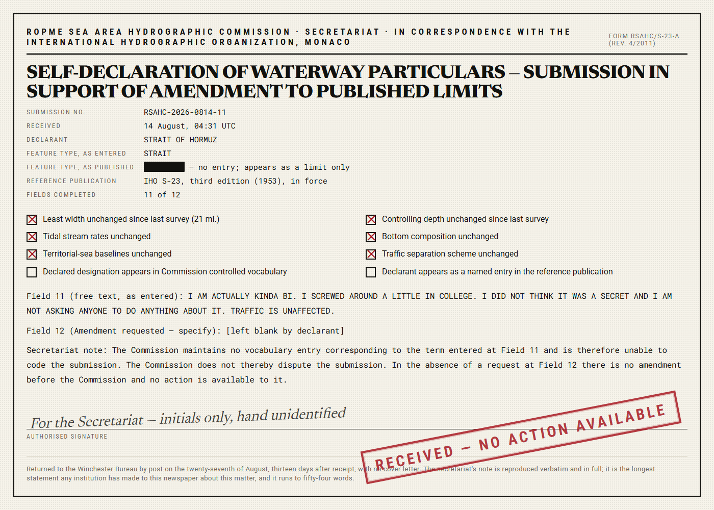
Which raises the question of what, exactly, would be amended, and on whose form. The answer arrived on the twenty-seventh of August, by post, from the Commission secretariat, in the envelope described at Section I. It is a two-page self-declaration form and it is mostly complete.
Eight of the eleven checkboxes are marked. The particulars are unchanged. The scheme is unchanged. The least width is unchanged. The baselines are unchanged. Three boxes are not marked: box 7, because the declared designation is not in the Commission's controlled vocabulary; box 8, because the declarant is not a named entry in the reference publication; and box 11, which is dealt with at Section I.
Field 12 is headed Amendment requested (specify). It is blank. The strait is not asking for anything. We photographed the field anyway, because that is what this newspaper does with a blank field, and we would observe that a party seeking an advantage from a disclosure usually writes something in the box provided for it.
VI. The Insurers
Cormac Whibley has underwritten marine war risks in the London market for twenty-six years. He returned our call on the first attempt, which almost nobody in this story did, and gave us eleven minutes, which he asked us to note.
The additional war-risk premium quoted for a laden very large crude carrier transiting the strait was 0.42 percent of hull value on the thirteenth of August. On the fifteenth it was 0.42 percent. On the twenty-ninth it was 0.41 percent, and Mr. Whibley attributes that movement to a matter unrelated to this story which he declined to discuss.
He asked us twice whether the disclosure was the whole of our inquiry. We confirmed that it was.
"Rates move when hulls get hit. That is the list. That is the entire list." — Cormac Whibley, war-risk underwriter, London market
Asked whether any underwriter in the market had raised the matter in any forum, Mr. Whibley said that none had, that he would have heard, and that he would like to return to his morning. He is the only person in this story who was faintly irritated with us, and on reflection we think he was entitled to be.
VII. The Hydrographer
Dr. Ingeborg Halvorsen-Tate spent thirty-one years with a national hydrographic office, the last eleven in survey standards, and now teaches. She gave us seventy-one minutes and explained the same point three times, in three different ways, and at no stage did she sound impatient, which we mention because this newspaper has transcribed a great many interviews and it is unusual.
Her point is that waterways are classified by physical characteristics. A strait is described by its least width, its controlling depth, its tidal stream rates, the composition of its bottom, and the position of the baselines either side of it. Every one of those is a measurement, taken by a survey vessel, recorded against a datum, and reduced by a published method.
"Self-description is not a hydrographic input," she said. "I want to be careful, because I am not saying it is untrue. I am saying there is no column for it. If you handed me that statement and asked me to enter it, I would ask you where."
She was insistent — repeatedly, gently insistent — that this is not a judgment on the declarant and should not be printed as one. We print that caveat in her framing, at her request, because it is true.
We thanked her. Then we asked her who updates the chart.
Her answer occupied nine minutes and reduces to this: nobody, because nothing has changed. A Notice to Mariners exists to tell a mariner something that will alter how the vessel is steered. Nothing here alters how anything is steered. There is therefore no notice, and no defect for a notice to correct. "It is not a refusal," she said. "People keep hearing a refusal. There is simply no notice, because there is nothing a notice is for."
We searched the Notices to Mariners for weeks thirty-three through thirty-six anyway. There is nothing relating to the strait, correctly.
VIII. Whether a Chokepoint Can Have a Past
The most serious objection put to us is not an objection to the disclosure. It is an objection to the second sentence, and it deserves to be argued rather than waved past. The objection is that a strait cannot have screwed around in college because a strait cannot have a college, a past, or a personal history of any kind, being a geographic interval rather than a biography. Professor Eamon Quist-Arcelay, a historical geographer of twenty-two years' standing, does not accept the premise.
He points out that this strait has a past documented in the sediment. The Persian Gulf basin was substantially dry land during the last glacial maximum. It flooded as sea levels rose through the early Holocene, reaching roughly its present extent some six thousand years ago. For much of its existence the thing we now call the Strait of Hormuz was not a strait at all. It was a river valley, and a river ran down it to the Gulf of Oman.
"We have been writing the biography of this water for two hundred years. Nobody has ever objected to that. The only new thing here is that the subject has now written one sentence of it, and I would gently suggest that the objection people are reaching for is not an objection to the biography. It is an objection to the pen." — Prof. Eamon Quist-Arcelay, historical geographer
The counter-argument is strong and this newspaper prints it in full. Asked about this directly, Dr. Halvorsen-Tate observed that the name attaches to a place and not to a substance, and that the water presently in the strait is exchanged by tidal flow on a cycle measured in days. The water that was in college, she said, is in the Indian Ocean.
We find that argument formidable. We would only note, in fairness, that it applies with equal force to everyone who has ever made a disclosure about their own past, the atoms not being the ones that were there either, and that no registrar in the world has ever accepted it as a defense.
IX. What We Are Not Saying
Reality Daily wishes to be exact, because this story will be summarized by people who have not read it.
We are not saying anything is wrong. Nothing is wrong. We interviewed nine people and not one thought anything was wrong, including the two with the standing to say so and the one who was annoyed with us.
We are not saying the disclosure is doubtful. We have not tested it and would not know how. The Standards Desk declines to characterize a single word of it, and declining to characterize a word is not doubt; it is the absence of a column.
We are not saying shipping is affected. Shipping is not affected. Premiums are unchanged to within a hundredth of a point, passage times to within two minutes, and the scheme has not moved a yard since 1993.
We are not saying the International Hydrographic Organization has done anything improper. We are saying we have asked it a single question twice, that the question is answerable in one sentence, and that a reference number is not a sentence.
And we are not saying a chokepoint cannot have a college. We are saying we could not find the college, that we tried for two weeks, and that we have stopped.
X. Conclusion
Thirty-four words, transmitted at 04:12, acknowledged at 04:31, never added to. A traffic separation scheme with four amendments in forty-seven years, none from this year. A transit log showing 1,247 passages at two minutes off the running mean. A war-risk sheet moving a hundredth of a point for an unrelated reason. A form with eight boxes marked and three unmarked, and a blank field where an amendment request would go.
And underneath it, the finding this newspaper did not expect and cannot get past: in the standard reference work on the limits of the world's waters, published in 1953 and never superseded, the busiest strait on earth has no entry of its own. It is the space where the Persian Gulf stops.
A body of water carrying a fifth of the world's oil made a short, calm, unsolicited statement about itself, asked for nothing, and met an international system of registers with no field to put it in and no procedure for saying so. That is not a scandal. Nobody behaved badly. It is a filing gap, and it is fifteen thousand years wide.
■ ■ ■
Reality Daily invites the International Hydrographic Organization to answer the Standards Desk's question. We will print the answer in full, unedited, at any length they choose, at the foot of this story, with no commentary from us whatsoever.
We also invite the declarant to elaborate, on any point, at any time, and we want to be clear that we are not asking it to. Four requests is where we stopped and where we intend to stay. If the answer is that there is nothing further to say, we will print that we were told there was nothing further to say, and treat it as a complete answer, because it is one.
The space has been held open since the nineteenth of August. It remains open. In the meantime the lanes are two miles wide, the separation zone is two miles wide, the strait is twenty-one miles across, and everything is where it was.
Corrections & Clarifications
Update, 06:22 — An earlier version of this article gave the least width of the strait as approximately twenty-one miles. Following a full review against four sailing directions and the published scheme, the least width is approximately twenty-one miles. The original wording stands.
Update, 10:47 — We initially reported the statement as running to thirty-one words. The Document Desk's certified count is thirty-four words. We regret the imprecision and note that it does not affect the finding, which was that the word "kinda" appears once, and which remains that the word "kinda" appears once.
Update, 15:31 — A reader has written to observe that the Strait of Hormuz is a strait. Reality Daily agrees, said so in the fourth paragraph, has never disputed it, and thanks the reader for confirming that our fourth paragraph is being read.
Sources & Documentation
- Statement of the declarant, received 14 August, 04:12 UTC. 34 words. Reproduced in full at Section I; original transmission retained by the Document Desk with headers and byte count intact.
- ROPME Sea Area Hydrographic Commission secretariat, acknowledgment of receipt, 14 August, 04:31 UTC. Reference RSAHC-2026-0814-11. 17 words.
- Form RSAHC/S-23-A (rev. 4/2011), Self-Declaration of Waterway Particulars, as filed. 2 pp. Reproduced at Exhibit B. Eleven of twelve fields completed.
- International Hydrographic Organization, Special Publication S-23, Limits of Oceans and Seas, third edition, 1953. The edition in force. The declarant has no entry.
- International Hydrographic Organization, draft fourth edition of S-23, circulated 1986, never adopted. Consulted in full for completeness. The declarant has no entry there either.
- International Hydrographic Organization, Special Publication S-32, Hydrographic Dictionary. Searched entry by entry. The word "kinda" does not appear.
- International Maritime Organization, Ships' Routeing, traffic separation scheme in the Strait of Hormuz as adopted 1979 and as currently in force, with all amendments. Compared line by line, twice. The spelling "routeing" is the Organization's own, is the settled term of art in the field, and is retained in all five instances in which it appears in this story; the copy desk has been instructed to stet it.
- Reality Daily Economics & Data desk, Hormuz Transit Log, 65,000 passages over 24 months. Basis for Section II and for the callout figures.
- al-Rashdi, A., Capt. Recorded telephone interview, 21 August, conducted at anchor. Transcript 14 pp. Reviewed and approved by subject.
- Halvorsen-Tate, I., Dr. Recorded interview, 25 August, 71 minutes. Transcript 39 pp. Caveats printed in her own framing at her written request.
- Whibley, C. Recorded telephone interview, 19 August, 11 minutes. Transcript 6 pp. Duration noted at subject's request.
- Market quotation sheets, additional war-risk premium, laden VLCC Hormuz transit, 13, 15 and 29 August. Three sheets, one page each. 0.42, 0.42 and 0.41 percent of hull value.
- Quist-Arcelay, E., Prof. Recorded interview, 27 August, 64 minutes. Transcript 28 pp.
- Reality Daily Standards Desk, Register Search Log: Fourteen Controlled Vocabularies Searched for the Word "Kinda." 9 pp. Result: zero occurrences in fourteen of fourteen.
- Reality Daily Standards Desk, correspondence to the International Hydrographic Organization, Monaco, 19 August and 2 September. One automated acknowledgment carrying a reference number and no text. Zero substantive responses.
- Reality Daily Standards Desk, Memorandum: On the Term Entered at Field 11 and the Desk's Inability to Characterize It. 3 pp. Reproduced in part at Section III.
- Correspondence with four institutions holding maritime or hydrographic programs and two international associations of registrars, 16–29 August. Six replies, all courteous, none responsive. 11 pp.
- Requests for elaboration transmitted to the declarant, 15, 16, 18 and 22 August. Four requests. No response to any.
- Memorandum of the Editor-in-Chief, On Whether the Twelve-Request Rule Governs a Party That Has Already Spoken. 1 p. Ruling: it does not. Four requests were made.
- Peer-reviewed literature on the flooding of the Persian Gulf basin through the early Holocene and the paleo-channel beneath it. Six papers, consulted for Section VIII.
- National hydrographic office, Notices to Mariners, weeks 33 through 36. Searched in full. No entry relating to the strait, correctly.
- Photograph, Field 12, Form RSAHC/S-23-A, recto. Reality Daily Document Desk, 4,096 × 3,072 px, EXIF intact. The field is blank.
- Reality Daily Document Desk intake log, entry of 14 August, 4 lines, including the marginal note shipping? standards? ask M.
- Reality Daily Legal, Memorandum on the Publication of a Statement Made Voluntarily by a Declarant of Uncertain Legal Personality. 2 pp. No objection raised.
- Reality Daily reader correspondence file RD-C-5518. 2,904 letters received since first publication of this story.
- The strait. It is twenty-one miles across at the narrowest and it said what it said.
Reader Response — 4,120 comments
I do chart corrections for a fleet of forty-one ships. The Notices to Mariners point is correct and it is the part everyone is going to skip. A notice exists to change how you steer. If nothing changes how you steer there is no notice, and there is no mechanism to issue one for information only, and there never has been. People keep reading the silence as an institution refusing to say something. It is an institution that has no envelope for it. Those are not the same and the paper is right that they are not the same.
I schedule vessels through there. Nothing changed. I want to be very clear that I mean that warmly.
You have written three thousand words about a strait's disclosure and not one of them is about the disclosure. Every single one is about a form. This is the most Reality Daily thing that has ever happened and I say that as a subscriber of four years.
@T. Okabe-Ferris — Correct, and thank you. The disclosure required no reporting from us; it was made plainly, in thirty-four words, by the party best placed to make it, and we have neither the standing nor the inclination to examine it. The forms are the only part nobody could account for. That is the story, and we accept that it is a strange one to have.
Hydrography postgrad. Can confirm the S-23 detail because I have to explain it to somebody roughly once a month. Third edition, 1953, still the edition in force. The fourth has been sitting in draft since 1986 over an argument about the name of a completely different sea. Seventy-three years. We are navigating the modern world on a book older than my department.
"Kinda" is just a contraction of "kind of." File it as "kind of" and the vocabulary problem goes away. Surely somebody at the Commission thought of this.
@Alistair Kwak It does not go away, because the register has no field for a qualifier of any strength. There is no box for "kind of" either. There is no box. That is the entire Section V and you have just written it again from scratch.
Good for it, honestly. Also I would like to know which college.