Two Cubic Miles of Water Have Turned Up in Lake Superior Since 1974 and Nobody Ordered Them
Lake Superior stands four inches above this newspaper's reading of the 1974 record, reduced to the current datum three separate times. Across 31,700 square miles that is two cubic miles of water. Fourteen weeks of inquiry produced a complete scientific explanation, a records request answered in four business days, and no document in which any party accepts responsibility for a single gallon.
Editor's Note
This audit was held for six weeks while the Standards Desk re-reduced the 1974 tabulation to the datum currently in force, a step we took three times, using three unconnected parties, at our own expense, before we were willing to print a number. Readers who intend to raise the datum objection are asked to read Section II first, where we raise it against ourselves and dispose of it.
One further note, which is unusual for this newspaper. The binational secretariat named in this story answered our records request in four business days, in full, without a fee, and offered us more. We have printed their letter unedited, including the sentence that cuts against us. Where an institution behaves well, we intend to say so at the top rather than at the bottom. — P. A. Doggett
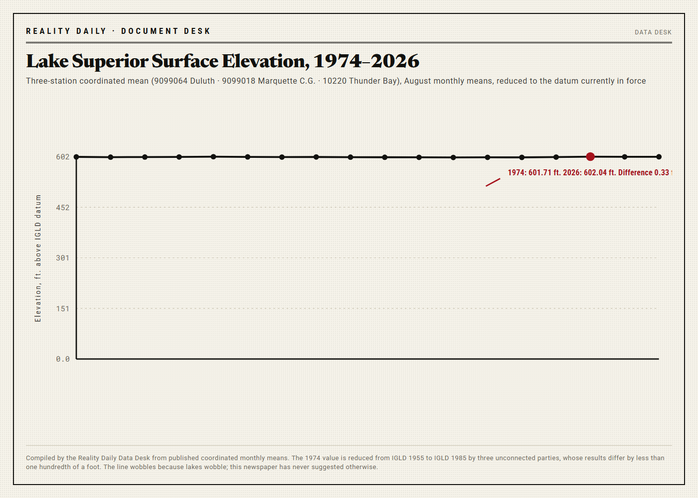
At 08:00 Eastern on the fourteenth of August, the water-level gauge on the federal pier at Duluth, Minnesota — station 9099064, stilling-well installation, shaft encoder serial SE-4471-B, sampled at six-minute intervals and averaged to the hour — reported a Lake Superior surface elevation of 602.04 feet above the International Great Lakes Datum.
Reality Daily's Document Desk compared that figure against the monthly mean recorded at the same station in August 1974, which we obtained on paper, in the original tabulation, from a coordinated binational archive that has never to our knowledge been accused of an error and which we are not accusing of an error now. Reduced to the datum currently in force by three parties working separately and without conferring, the 1974 figure is 601.71 feet.
The difference is four inches.
We want to concede the smallness of that number before anybody else raises it. Four inches is the depth of a bathroom sink. It is shorter than a pen. A person standing in Lake Superior would not perceive it, and this newspaper is not suggesting that anyone ought to have.
Lake Superior, however, covers approximately 31,700 square miles, which is to say that it is very nearly the size of South Carolina. Four inches distributed across a surface of that size is a quantity of water that our Economics Desk has computed to seven significant figures, had checked by two staffers neither of whom was told the other was checking, and printed below in four different units, because we have found that readers believe the fourth one.
We would like that quantity attributed to a source in writing. That is the entire request. It has been the entire request since June.
"In my trade you do not close out a tank that is four inches off. You stop, and somebody signs. Nobody has ever handed me a tank the size of South Carolina."— Rayburn Stellhorn, retired custody-transfer measurement supervisor, Whiting, Indiana
I. The Reading, and the Reading It Is Measured Against
The Great Lakes are among the best-instrumented bodies of fresh water on earth, and we want that on the record in the first paragraph of the first section rather than buried in a concession near the end. The United States Army Corps of Engineers and Environment and Climate Change Canada jointly operate a coordinated gauge network around the basin. Readings are referenced to the International Great Lakes Datum. Monthly means are published. They have been published continuously for longer than anyone now working at this newspaper has been alive.
Our Document Desk pulled three stations rather than one, on the theory that a single gauge is an anecdote. Duluth, Minnesota (9099064). Marquette C.G., Michigan (9099018). Thunder Bay, Ontario (10220). The three stations do not agree exactly, and they are not supposed to; the lake is not a bathtub, and it is pushed around continuously by wind, barometric pressure, and a phenomenon called seiche that we had to have explained to us twice.
Averaged and reduced, the three stations agree to within six hundredths of a foot. That is a well-run network. We are saying so plainly because we intend to say some less flattering things later and we do not want them mistaken for a complaint about the instruments.
The August 1974 monthly mean, on the same three stations, reduced the same way, comes out four inches lower than the reading of the fourteenth of August this year.
Four inches. Not four feet. Four inches, over fifty-two years, on a lake that has done considerably more dramatic things than that in the interval and has done them on schedule.
II. The Datum, Which We Raised Against Ourselves
The first objection to this story is the datum, and we know it is the first objection because we raised it ourselves, in week one, in an internal memorandum that our Standards Desk circulated before a single interview was conducted.
The 1974 tabulation is recorded against the International Great Lakes Datum of 1955. The current reading is recorded against the International Great Lakes Datum of 1985. These are not the same reference surface. A datum is a decision about where zero is, and in 1985 the two countries made a different decision than they had made in 1955, for good and published reasons having to do with the fact that the land itself is moving.
The land itself is moving. We will come back to that. It is the single most interesting fact in this story and we found it in a footnote.
Reality Daily commissioned three independent reductions of the 1974 figure to the 1985 datum: one from a retired geodesist, one from a Canadian surveying consultancy that asked not to be named in a story of this kind, and one from our own Data Desk working from published conversion tables and nothing else. The three reductions differ from one another by less than one hundredth of a foot.
The four inches survives all three. We would have printed it if it had not. We had the correction drafted.
Standards Desk note on the datum, 19 June
"The datum objection is correct in principle and does not dispose of the finding. A change of reference surface moves both readings or neither. Ours moves both. The residual after reduction is 0.33 feet, which is four inches, which is the number in the headline."
"We note for the file that a third datum, IGLD 2020, is in progress. When it is adopted we will re-reduce everything and publish whatever we get, including a null result, and we will publish it with the same prominence."
III. The Volume, Computed
Here is the arithmetic, which is the only part of this story that is not in dispute anywhere by anyone.
A surface of 31,700 square miles contains 883,745,280,000 square feet. Four inches is one third of a foot. The product is the volume of water that now sits above the 1974 line.
294,581,760,000 cu ft = 2,203,625,000,000 gal
Two hundred ninety-four billion, five hundred eighty-one million, seven hundred sixty thousand cubic feet. Two trillion, two hundred three billion, six hundred twenty-five million gallons. Six million, seven hundred sixty-two thousand, six hundred sixty-seven acre-feet.
And, because our Economics Desk found the coincidence too tidy to leave out and then spent an afternoon confirming it was a coincidence: 2.001 cubic miles.
Economics Desk, computation RD-ECON-3312, checked twice
Surface: 31,700 sq mi (published). Depth increment: 0.3333 ft. Volume: 294,581,760,000 cu ft; 2,203,625,000,000 US gal; 6,762,667 acre-ft; 2.001 cu mi.
For scale only, and asserting nothing: at published national rates, the volume above is approximately fifty-six days of total public water supply withdrawal for the United States of America.
We are aware that this is roughly seven hundredths of one percent of Lake Superior, which holds something on the order of 2,900 cubic miles and which turns over about once every 191 years. We printed the percentage ourselves, unprompted, in the second paragraph of our first letter. It remains two cubic miles of water and nobody has said where it came from in a document.
IV. The Hydrologist Is Correct About Everything
Dr. Ruthanne Kivelä-Ostrom is a surface-water hydrologist who has worked the Superior basin for twenty-six years. She answered our first email in under two hours, offered us ninety minutes and gave us four, sent follow-up material we had not asked for, and at no point during any of it treated this newspaper as a nuisance, which we want stated because it is not our usual experience and she did not have to.
She explained the water balance completely. We are going to reproduce her explanation at length, because it is correct, because it is the best part of this story, and because we do not want to be accused later of having hidden it.
Water arrives in Lake Superior three ways. It falls on the lake as precipitation. It runs off a land drainage area of roughly 49,300 square miles. And it comes in as groundwater, which is small and which she was careful to say is small. Water leaves two ways: through the St. Marys River at Sault Ste. Marie, and by evaporation off the surface, which over a lake this cold is not a summer phenomenon at all but a late-autumn and winter one, driven by the temperature difference between air and water and suppressed in years of heavy ice cover. Low ice, high evaporation. The lake breathes out in November.
She then explained the thing we had found in a footnote and had not believed. The bedrock of the basin is still rising, unevenly, from the removal of an ice sheet that has been gone for ten thousand years. The northeast rises faster than the southwest. A gauge at Duluth is therefore, very slowly, going down relative to the outlet, and a level that appears to be rising at one end of the lake is in part a shoreline sinking at that end. Glacial isostatic adjustment. It is measured in millimetres per year and it is real and it is in the datum.
She gave us the residual, the net basin supply, the connecting-channel flows, the standard error on each, and the reason the mid-2000s were low and 2019 and 2020 were records. She was right about all of it. Our Standards Desk checked her against six published sources and found no daylight.
We thanked her, and we told her what we wanted, which was a document naming the party responsible for 2,203,625,000,000 gallons.
There was a pause on the line that our transcript logs at eleven seconds.
"It came from the sky. I know that isn't a name."— Dr. Ruthanne Kivelä-Ostrom, surface-water hydrologist, at the end of an eleven-second pause
Dr. Kivelä-Ostrom described a process. We had asked for a party. We want to be very clear that the failure in that exchange is not hers, and that she is the best-informed person in this article by a wide margin, and that she answered every question we were competent to ask.
V. What a Gauge Knows
Wendell Poirier serviced hydrologic instruments on the Superior and Huron shorelines for thirty-four years. He is retired. He lives outside Ashland, Wisconsin. He returned our call at 6:40 in the morning, which he apologized for and which we did not mind.
We asked him whether a gauge could tell us where water came from.
"No," he said.
We asked him to expand, and he did, at length and without impatience, and the expansion is the most useful description of an instrument that anyone gave us. A stilling well is a pipe with a hole in it. A float sits in the pipe. The float goes up and the encoder counts. In a bubbler installation there is no float at all, only a pressure reading off a submerged orifice line, and the pressure does not know anything either.
"It measures how high the water is in a pipe," he said. "That's the whole job. It doesn't know it's a lake. It doesn't know what fell where. It doesn't know what year it is unless somebody sets the clock, and I've seen the clock be wrong."
We asked whether, in thirty-four years, anyone had ever asked him where the water came from.
"A gauge is a witness that only saw the last six minutes. You can ask it anything you want. It's going to tell you the same number."— Wendell Poirier, hydrologic technician (ret.), Ashland, Wisconsin
VI. Four Business Days
On the third of June, Reality Daily filed a records request with the secretariat of the binational board that oversees the regulation of Lake Superior's outflow. We asked for eight things. Seven of them were records. The eighth was a question.
We want to describe what happened next accurately, because our newsroom has not entirely recovered from it.
The request was acknowledged the same afternoon, by a person, with a name. Four business days later we received 1,140 pages: the coordinated gauge record for three stations from January 1974 to the present, every monthly mean tabulation, the regulation plan currently in force, the minutes we had asked for, and two documents we had not asked for but which we wanted. Nothing was withheld. There was no fee. The covering letter closed by offering us a briefing at our convenience.
This newspaper has filed a great many records requests. We know what refusal looks like. We have an internal memorandum on the difference between "no" and silence which is in its sixth revision and which is required reading here. We did not have a memorandum for this.
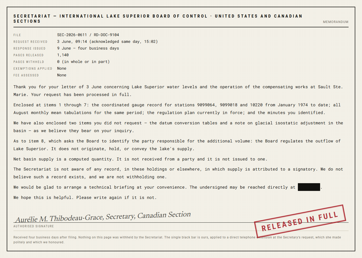
The eighth item — the question — was answered too, in three sentences, courteously, and it is the reason this story exists in the form it does. The Board regulates outflow. It does not originate, hold, or convey the lake's supply. Net basin supply is a computed quantity; it is not received from a party and it is not issued to one, and the secretariat is not aware of any record in which supply is attributed to a signatory.
Eleven hundred and forty pages arrived in four business days, and in none of them does any party accept responsibility for a single gallon. That is not obstruction. It is worse than obstruction, in a way we are still trying to put properly: everything we asked for came, on time, complete, and the document we wanted turned out not to be a document that anybody makes.
VII. Regulated, Owned, and Signed For
Outflow from Lake Superior is regulated. This is genuinely true and it is the fact that started our reporting. There are compensating works at the head of the St. Marys River at Sault Ste. Marie; there are gates; there is a plan; there is a board that meets and decides how much water leaves the lake each month and writes down what it decided. Somebody signs that.
Nobody signs for what arrives.
Lorraine Sczepanik-Doyle spent twenty-eight years abstracting titles in northern Michigan. She asked us three times to note that she is describing state property law, that she is not a hydrologist, and that she has never worked on a matter of this kind. All three are printed at her request.
What she then described is the ordinary law of a lakeshore. The bottomlands are in the deed, or they are held by the state in trust, depending on the jurisdiction and the era of the patent. The water is not in the deed. Water is held in public trust, which means it is held for everybody, which means, as a matter of filing, it is held by nobody in particular.
"You can own the bottom," she said. "The wet part isn't conveyed. It's never been conveyed. There's nothing to convey it on."
We concede without reservation that water is not the kind of thing that has a signatory. It is not a shipment. It has no bill of lading, no consignor, no receiving clerk. A cloud does not initial anything. Every person we interviewed made some version of this point and every one of them was right.
We would only observe that two cubic miles of it arrived, that it is on an instrument record maintained by two national governments, that its arrival is regulated at the far end by an international board that keeps minutes, and that in eleven hundred and forty pages of those minutes there is not one line in which anybody says where it came from and puts their name under it. If a thing that cannot have a signatory nevertheless has a gate, a plan, a board and a datum, we do not think it is unreasonable to ask who signs.
VIII. Class 6
On the eleventh of August our Standards Desk was asked to characterize the four inches for the purposes of the house style guide, and declined.
The Desk would not call the volume accounted for. Every mechanism by which it could have arrived has been described to us competently, in detail, by a hydrologist we believe, and the description is complete. That is a strong position and the Desk said so in writing.
The Desk would not call it unaccounted for either. That phrasing implies an absent record, and no record is absent. Everything that exists was produced to us in four business days by people who were pleasant about it.
Reality Daily's standards manual has, until this month, recognized five classes of finding. The Desk has opened a sixth.
CLASS 6 — ATTRIBUTED TO A PROCESS, NOT TO A PARTY
The classification carries no accusation and cannot be cited as one. It means only this: that the thing is fully explained and unsigned, and that our house style will no longer pretend those are the same condition.
IX. What We Are Not Saying
Reality Daily wishes to be exact, because this story will be summarized by people who have not read it and by a few who will decline to read it as a matter of principle.
We are not disputing hydrology. We accept it entirely, we have said so four times already, and we say it a fifth time here: precipitation, runoff, evaporation and ice cover are the drivers, Dr. Kivelä-Ostrom explained them correctly, and this newspaper has no scientific quarrel with any part of her account.
We are not saying the water is missing. Nothing is missing. There is more of it than there was, which is the opposite of missing, and any summary of this reporting that uses the word "missing" is describing something we did not publish.
We are not saying the gauge network is unreliable. It is the most reliable thing in this story. Three stations, two countries, six hundredths of a foot of spread. We would like the rest of American public life run to that standard.
We are not saying the binational board did anything but answer us fully, promptly and free of charge, and we have printed their letter in full and unedited above, including the sentence that undermines the premise of our own inquiry.
We are not alleging that anybody has taken anything, sold anything, hidden anything, or profited from anything. The word "theft" does not appear in fourteen weeks of internal memoranda on this audit, and our Standards Desk has confirmed that line by line and will produce the file.
We are saying that Lake Superior is four inches higher than our reading of the 1974 record, that four inches across 31,700 square miles is two trillion, two hundred three billion, six hundred twenty-five million gallons, that every institution we asked described how such a thing happens, and that not one of them would write down that it happened and sign underneath.
X. Conclusion
The lake is fine. We want that sentence to sit by itself, because it is true and because nothing else in this story qualifies it.
What we have is a volume, computed to seven significant figures and checked twice, sitting on top of a fifty-two-year-old tabulation that was reduced to the current datum three separate times by parties who did not speak to each other. What we have alongside it is a complete, courteous, unclassified explanation of the physical process by which such volumes arrive, given freely by the best-qualified person we could find, who is right.
What we do not have, and what fourteen weeks of work has established does not exist anywhere in the holdings of either national government or of the board that sits between them, is a single line of paper on which any party says: this water is ours, we brought it, here is the figure, here is the date, here is the name.
Two cubic miles. Six million, seven hundred sixty-two thousand, six hundred sixty-seven acre-feet. Fifty-six days of the national water supply. Explained perfectly. Signed by no one.
■ ■ ■
Reality Daily extends to the United States Army Corps of Engineers, to Environment and Climate Change Canada, to the International Joint Commission, to the secretariat that answered us in four business days, and to any officer or employee of any of them, unlimited space at the foot of this page. We will print any response in full, unedited, at any length whatever, in the same typeface and at the same size as this story, with no commentary from us of any kind.
We will also accept a form. If any body wishes to create one — a single sheet on which a quantity of net basin supply is stated, dated, and initialled by a person with the authority to initial it — we will print the blank form at the top of this article, at full width, and we will consider the matter closed the same afternoon. Our Document Desk has drafted a specimen and will supply it on request, without conditions.
The space has been held open since the third of June. The lake, in the meantime, continues to arrive.
Corrections & Clarifications
Update, 06:31 — An earlier version of this article described the difference between the 1974 and current readings as "four inches." Following a complete re-reduction of the 1974 tabulation to the datum currently in force, performed a third time and by a party unconnected to the first two, the difference is four inches. The original wording stands.
Update, 10:09 — We initially printed the volume as 2,203,624,000,000 gallons. A recomputation, performed twice and by two staffers who did not confer, returns 2,203,625,000,000 gallons at seven significant figures. We regret the understatement of approximately one billion gallons, have added the figure to the computation log, and note that it does not affect the finding, which was that nobody will sign for any of it.
Update, 15:18 — A reader writes to note that Great Lakes levels fluctuate naturally on multi-year cycles and that 2019 and 2020 set record highs after record lows in the mid-2000s. Reality Daily agrees, said so in Section IV, plotted both the lows and the highs at full height in Fig. 1, and thanks the reader for confirming that Fig. 1 is being examined.
Sources & Documentation
- Reality Daily Data Desk. Three-Station Coordinated Elevation Series, Lake Superior, August Monthly Means, 1974–2026. 62 pp. Stations 9099064, 9099018, 10220. Compiled from published coordinated records.
- United States Army Corps of Engineers, Detroit District, and Environment and Climate Change Canada. Coordinated Great Lakes water level records, obtained in full via records request SEC-2026-0611 / RD-DOC-9104. 1,140 pp. Released in full; no exemptions; no fee.
- International Great Lakes Datum of 1955; International Great Lakes Datum of 1985. Conversion tables as supplied by the Secretariat, unrequested, with the response above.
- Kivelä-Ostrom, R., PhD. Recorded interview, 24 June, four hours in two sessions. Transcript 71 pp., reviewed and approved by subject, with two clarifications she asked us to add and which we added.
- Kivelä-Ostrom, R. Supplementary material provided unprompted, 25 June: eleven references on over-lake evaporation, ice cover, and net basin supply. All eleven consulted.
- Poirier, W., hydrologic technician (ret., 34 yrs). Recorded telephone interview, 2 July, 6:40 a.m. CDT. Transcript 22 pp.
- Stellhorn, R., custody-transfer measurement supervisor (ret.). Recorded interview, 9 July, and written statement, 2 pp., on tank gauging tolerance and ticketing practice.
- Sczepanik-Doyle, L., title abstractor (ret., 28 yrs). Recorded interview, 14 July, with three caveats printed at the subject's request.
- Reality Daily Economics Desk. Computation RD-ECON-3312: Volume of a Four-Inch Increment Across 31,700 Square Miles. 4 pp. Checked twice, by two staffers, neither informed of the other.
- Reality Daily Standards Desk. Memorandum on the Datum Objection, Raised Internally in Week One. 6 pp., circulated before the first interview was conducted.
- Independent reduction of the August 1974 monthly mean to IGLD 1985, party one: geodesist (ret.), 3 pp.
- Independent reduction, party two: Canadian surveying consultancy, name withheld at the firm's written request, 5 pp.
- Independent reduction, party three: Reality Daily Data Desk, working from published tables only, 3 pp. Spread across all three reductions: under 0.01 ft.
- Secretariat, International Lake Superior Board of Control. Response letter, 9 June, 2 pp., reproduced in this article in full and unedited.
- Regulation plan currently in force for the outflow of Lake Superior, as supplied. Reviewed in full by the Document Desk.
- Reality Daily Document Desk. Line-by-Line Reading of 1,140 Released Pages for Any Attribution of Supply to a Named Party. 3 staffers, 19 days. Instances found: zero.
- Reality Daily Document Desk. Note on Glacial Isostatic Adjustment in the Superior Basin, confirmed against four independent sources after the finding was disbelieved internally.
- Reality Daily Standards Desk. Classification Determination: Opening of Class 6, "Attributed to a Process, Not to a Party." 4 pp. Sixth class in the manual's history.
- Reality Daily Standards Desk. Word-Frequency Audit of Fourteen Weeks of Internal Memoranda on This Audit. Occurrences of the word "theft": zero. Verified twice.
- Reality Daily Legal. Memorandum on Publishing a Records Response That Undermines the Requesting Party's Premise. 2 pp. Recommendation: publish it anyway, at full length, above the fold.
- Reality Daily Reader Correspondence File RD-C-6602, 1,847 letters received since this audit was announced. Nine enclose the writer's own volume computation. Seven agree with ours to the gallon.
- Reality Daily Document Desk. Specimen Net Basin Supply Attribution Form (Blank), Draft 3. 1 p. Offered to any body that wants it. No conditions. No credit sought.
- Reality Daily Standards Desk. Internal Memorandum, "On the Difference Between 'No' and Silence," rev. 6. Consulted. Found not to apply. A new memorandum has been opened.
- Reality Daily Standards Desk. Internal Memorandum, "On Being Answered Promptly," rev. 1, opened 9 June, 09:41. Two pages. Unfinished.
- The water. It is four inches higher. It came from the sky. That is not a name.
Reader Response — 6,312 comments
I have driven around that lake my whole life and it never once occurred to me that two cubic miles of water could show up over fifty years and there would be no piece of paper anywhere. The gauge guy is right. It only saw the last six minutes.
Working hydrologist, Great Lakes basin, eleven years. The isostatic adjustment paragraph in Section IV is correct and it is the part that everybody outside the field gets wrong. The northeast of the basin really is rebounding faster than the southwest, it really does mean a Duluth gauge reads differently over decades than a Thunder Bay gauge, and it really is inside the datum. I am not endorsing the rest of this article. I am saying that paragraph is right and I did not expect it to be.
Duluth. Canal Park. The high water in 2019 took out a chunk of the Lakewalk and we all watched it happen and rebuilt it and nobody at any point asked where the water came from, we just assumed somebody knew. Reading this at my kitchen table wondering why I assumed that.
Respectfully, this is three thousand words asking two national governments for a receipt for rain.
@A. Kowalczyk — Correct, and more efficiently put than we managed across ten sections. We asked two national governments and one international board for a receipt for rain. One of them answered in four business days, in full, at no charge, and told us plainly that no such receipt is issued by anybody. That is the story, and it is a better story than a refusal would have been. Your comment has been entered in the correspondence file at RD-C-6602.
"It came from the sky. I know that isn't a name." She said that after an eleven second pause to a man asking her to sign for a lake. I am putting it on a shirt. I put the lawnmower on a shirt and I regret nothing.
Quoted in the piece and I want to add one thing they left out because I asked them to keep it short. Four inches on a 55,000 barrel tank is about 400 barrels and it will stop a terminal cold at three in the morning until a human being initials a ticket. That is the standard I worked to for thirty-one years. I am not saying it applies to a lake. I am saying I notice that it does not.
Back again from the curtain and the hour. Wrote to the Corps this morning, politely, asking only for the form. Received a same-day reply thanking me and explaining net basin supply very kindly and at some length. Still no form. I have started a folder.