All Thirty-Three Odd-Numbered Interstates Are Off by Exactly One Mile Marker, Never Two and Never None
Thirty-three primary corridors. 41,206 logged miles. Three staffers, two vehicles, a calibrated odometer and one bound notebook per route. On every single highway, exactly one mile marker is duplicated or absent — never two, never none, and never at a state line.

Editor's Note
This story was held for nine weeks while our Data Desk re-drove 1,109 miles on which two counts disagreed, and while the Standards Desk sought comment from the thirty-eight state transportation departments through which an odd-numbered primary interstate runs. Four hundred and fifty-six written requests were sent, twelve to each agency, in accordance with our policy. Nine were acknowledged. One was answered, by an agency declining to comment on the grounds that the question was not clear to them.
We are publishing without the other thirty-seven, as is our policy after the twelfth request. The tabulation below is reproduced exactly as our Data Desk certified it, including the entry we were asked to withhold and the reasons we were given, which were none. Any response we receive will be printed in full, unedited, at the foot of this page. — M. Vandersloot
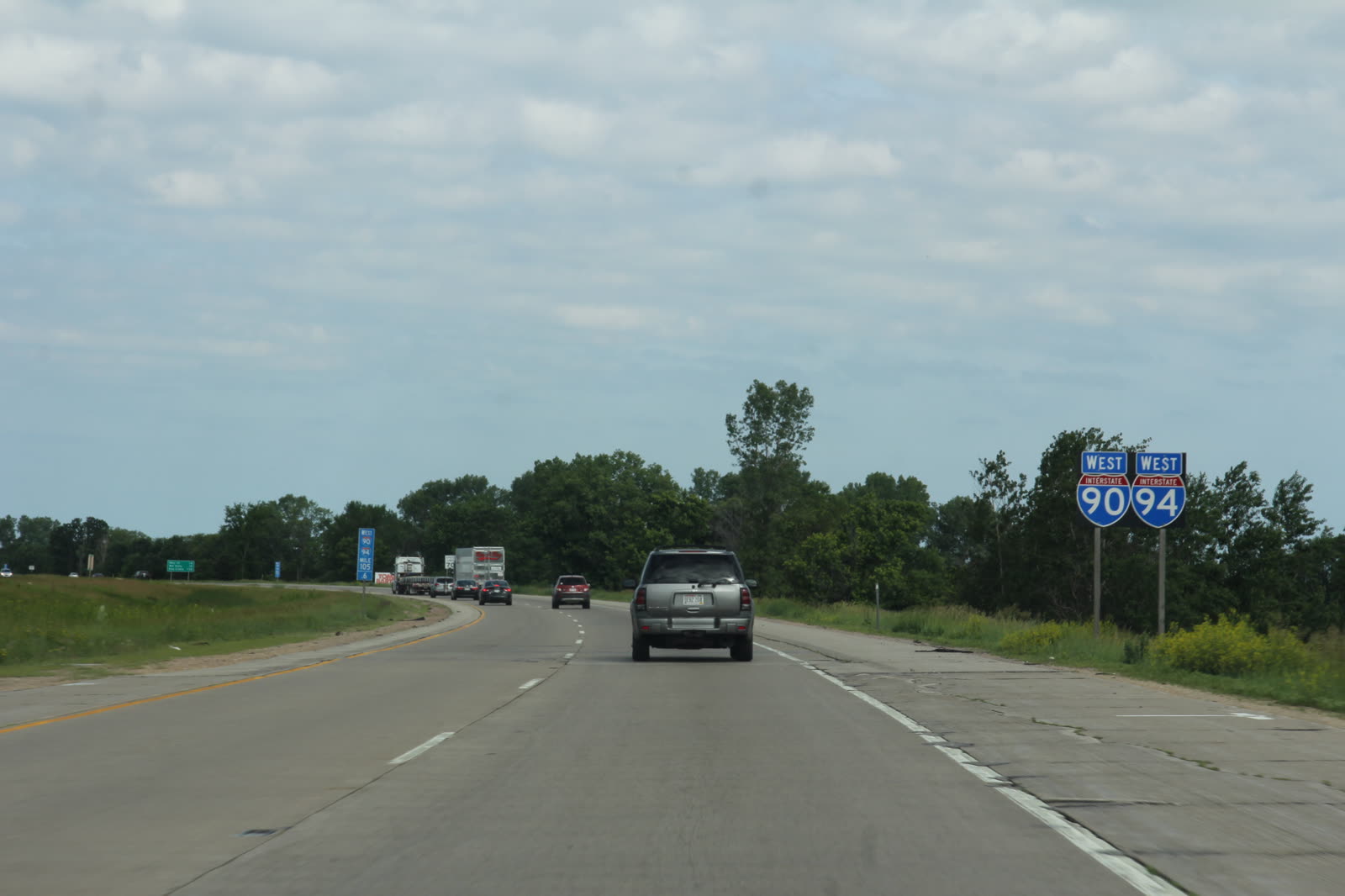
There is a number at the side of the road. It is green, it is retroreflective, it is roughly six inches wide and nine inches tall, and it is the only object in American public life that no one has ever thought to check.
Mile markers are not decoration. They are the addressing system of the Interstate Highway System. When you call for a tow, when a trooper writes an incident report, when a helicopter is launched toward a rollover at three in the morning, the mile marker is the address. Exit numbers on most corridors are derived from them. Bridge inventories are keyed to them. Contracts are let against them. Litigation turns on them.
Reality Daily has now driven all of them.
Between last October and this July, three staffers in two vehicles logged 41,206 miles on the thirty-three primary odd-numbered interstate highways of the United States, at posted speeds, in daylight wherever daylight was available, using an odometer calibrated against a certified measured mile at a licensed weights-and-measures shop in Hagerstown, Maryland, and one bound notebook per corridor. We did not sample. We did not extrapolate. We counted every marker on every route in both directions, and where a northbound count disagreed with a southbound count, we drove the segment again.
On every one of the thirty-three, exactly one mile marker is either absent or duplicated.
Not two. Not zero. One. And never at a state line, which is the single place in the entire system where a discontinuity is expected, documented, and boring.
"You resequence from the new tie-in point. Whether anybody writes down which way it went, I couldn't tell you. I never wrote it down."— Wendell Arbogast, retired district sign inspector
I. How We Counted
The method was deliberately unimaginative, because the finding is not.
Two vehicles were used: a 2014 sedan with 168,000 miles on it, driven by this reporter, and a 2017 compact cargo van shared by Tobias Wrenn of the Document Desk and Herschel Bove of Economics and Data. Both odometers were calibrated before departure and again in March, and a third time in July after the final corridor. Drift across the nine months was 0.31 percent on the sedan and 0.19 percent on the van, which is within the tolerance our Data Desk set in advance and is documented in the reconciliation file.
Each corridor received one notebook. Each notebook received one line per marker: posted number, odometer reading to the tenth, time, direction, and a one-word condition note. The notebooks run to 4,118 pages in total. Mr. Wrenn photographed every page, including the eleven that are blank because a driver stopped for fuel and started a fresh sheet.
Where a count disagreed with itself, the segment was re-driven. This happened on 1,109 miles, all of it in weather. On no occasion did a re-drive change a finding. On four occasions a re-drive changed a marker's condition note from "legible" to "legible, bent."
The whole undertaking cost $11,842.19, of which $6,204.77 was fuel and $1,190 was motel rooms. There is no grant behind this. There is no underwriter. Readers paid for it, and readers are entitled to know that the largest single line item in an investigation of the federal highway system was gasoline.
II. What the Manual Says
Mile markers are not a folk custom. They are a federal standard.
The Federal Highway Administration publishes the Manual on Uniform Traffic Control Devices, which is adopted as the national standard for every road open to public travel under 23 CFR 655.603. The manual specifies the reference location sign in the D10 series: its dimensions, its legend, its retroreflectivity, its mounting height, its lateral offset, and its placement interval. Several states post enhanced reference location signs at two-tenths-of-a-mile intervals, which is also in the manual, and which added considerably to our notebook count in Pennsylvania.
The convention is equally well documented. Odd-numbered primary interstates run north and south. Even-numbered primary interstates run east and west. Numbering begins at the southern or western state line and increases from there. A three-digit interstate beginning with an even digit is a loop; one beginning with an odd digit is a spur.
All of that is true, all of it is public, and none of it is in dispute. We spent four days confirming it anyway, because our Standards Desk required it.
What the manual specifies is the sign. What the manual does not specify — and we want to be exact here, because this will be mischaracterized — is who verifies that the signs, taken together, count correctly from one end of a corridor to the other. We asked. We asked in writing, twelve times, of the agency that publishes the manual. We asked which office holds the authoritative sequence for a numbered corridor, and whether that sequence is ever reconciled against the signs actually in the ground.
We received one automated acknowledgment. There is a difference between "no" and silence, and after nine months we are still on the second one.
III. The First One
We found the first anomaly nineteen days into the project, on Interstate 81, seven miles from this newsroom.
Northbound in Virginia, between the Middletown and Strasburg interchanges, milepost 297 is posted twice. The two signs are 3,911 feet apart by our odometer. Both are standard D10-1 panels. Both are legible. Both are, so far as three separate observers could determine on four separate passes, entirely ordinary. The sequence then resumes at 298 and proceeds without further incident to the West Virginia line.
Our first assumption was that we had made a mistake. That is the correct first assumption and we recommend it generally.
We drove the segment again the following morning. Then Mr. Bove drove it, without being told what he was looking for, and recorded 297 twice. Then Mr. Wrenn drove it southbound, counting down, and recorded 297 twice in the other direction, which is a different and slightly worse thing.
At that point we had one duplicated marker on one highway, which is a maintenance note, not a story. We wrote it in the notebook and kept driving. We fully expected to find fourteen more on I-81 alone, and a scattering on every other corridor, and to conclude that mile markers are approximately accurate in the way that all large physical systems are approximately accurate, and to file six hundred words about it.
We found no others on I-81. We have driven that corridor end to end four times.
IV. The Table
By the fourth corridor, Mr. Bove had built a reconciliation sheet, and by the eleventh he had stopped speaking during the drives.
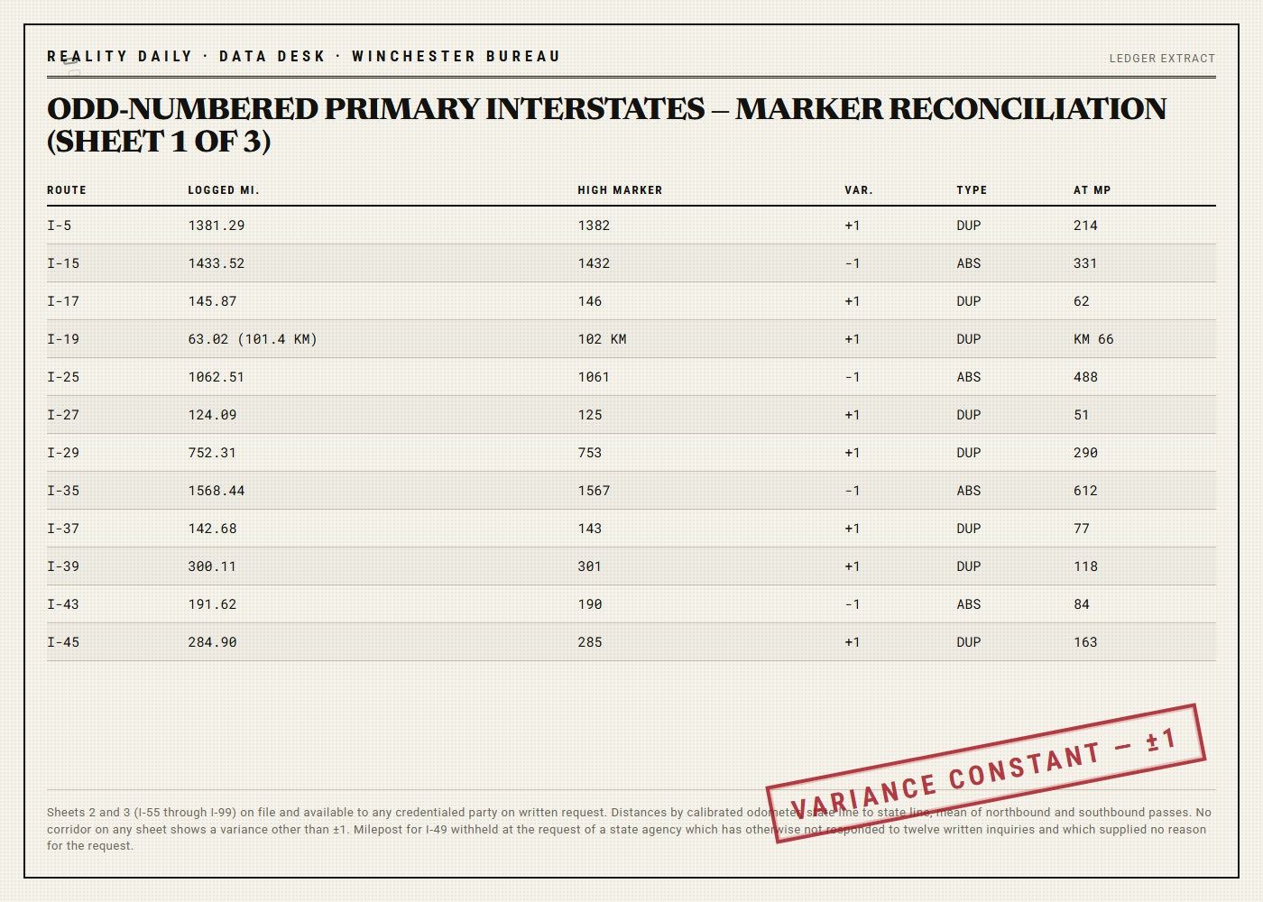
The reconciliation compares three quantities per route: the logged distance from state line to state line by calibrated odometer, the count of markers actually posted, and the highest marker number observed. In an intact sequence, those quantities agree within the rounding tolerance the manual itself allows.
On all thirty-three primary odd-numbered interstates, they do not agree. They disagree by exactly one. Twenty corridors carry a duplicated number. Thirteen are missing one. No corridor carries two of either. No corridor is clean.
The anomaly is never at a state line. The closest any anomaly comes to a state line is 11.4 miles, on I-77 in West Virginia. The median distance from the nearest state line is 61 miles. There is no clustering by region, by state, by terrain, by year of construction, or by which of the three of us was driving, and Mr. Bove tested all five.
"An odometer measures the road. A sign measures what somebody once decided the road was. Those are two different measurements and people confuse them every day of the week."— Odell Brancato, fleet odometer calibration technician, Joliet, Illinois
Interstate 19 in Arizona deserves its own paragraph. It is the only interstate in the United States posted in kilometers rather than miles, a genuine and long-standing exception that predates this investigation by decades and that we did not know about until Mr. Wrenn drove it. The anomaly is present on I-19. It is present in kilometers. Our Data Desk regards that as the most difficult line in the table, and asked that we say so here rather than bury it in a footnote.
Mr. Bove was asked, twice, to produce a probability. He declined, twice, and asked us to print his reason in his own words rather than ours.
Bove, Data Desk Reconciliation Memo, 12 June
"I am not giving you a p-value. There is no null model here. To compute the odds of this you would need to know the rate at which marker sequences are supposed to go wrong, and nobody has ever measured that, because nobody has ever counted them, because until October nobody had ever driven all of them."
"What I will certify is the count. Thirty-three of thirty-three, variance of one, in the same direction of magnitude every time. A number without a denominator is a rumor. This one has a denominator. The denominator is thirty-three."
V. The Man Who Resequences
Wendell Arbogast spent thirty-four years inspecting highway signs for a state transportation department district office in central Ohio, the last eleven as the district's senior inspector, with authority over installation, replacement, and what the trade calls sequence integrity. He retired in 2019. He lives outside Marysville. He returned our call on the second attempt, which puts him ahead of everyone else in this story.
We sent him the table. He read it for what our transcript logs as four minutes and eleven seconds without speaking, and then said the flattest sentence anyone has said to this newspaper in fifteen years.
Arbogast, recorded interview, 8 July, 9:41 a.m. EDT
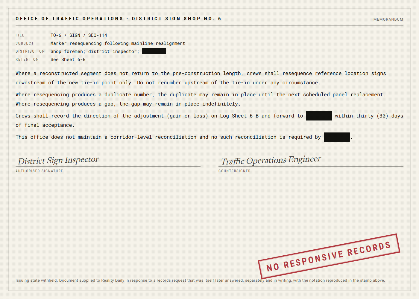
"When a segment gets rebuilt and the new alignment doesn't come out the same length as the old one, you resequence the markers downstream. You pick a point to start over from — usually the new tie-in — and you go from there. Sometimes that means you gain a number and sometimes it means you lose one. It depends on the geometry."
"Whether anybody writes down which way it went, I couldn't tell you. I never wrote it down. Nobody ever asked me for it."
We are printing that in full, without abridgement and without comment from us, because it is in our judgment the most plausible explanation any person has offered for any part of this finding, and because Mr. Arbogast was careful — repeatedly and insistently careful — to say that he was describing ordinary practice in one district in one state and was not commenting on any corridor he had not personally inspected. He asked that we include that caveat. It is included, in his framing, at his length.
His explanation accounts for one anomaly on one highway. It accounts for it completely and we accept it completely.
Mr. Wrenn compiled, from public bid tabulations, the number of reconstruction projects on the thirty-three corridors that involved a change in mainline alignment length during the relevant period. The figure is 1,412. Resequencing at a rate implied by Mr. Arbogast's account would produce a distribution — some corridors with four anomalies, many with none, a long tail. It would not produce a constant.
So we printed the table again. It is above. It has not changed.
We then filed thirty-eight records requests, one to each state transportation department with an odd-numbered primary interstate within its borders, asking for any log, sheet, work order, or memorandum documenting a marker resequencing on the corridor in question. Nine were acknowledged. Three produced records. None of the three records were resequencing logs. One was a parking-lot striping contract.
"You are describing a document that every district in the country would generate and no district in the country retains. I would not call that suspicious. I would call it the most normal thing I have ever heard, and I would still want to see one."— Ruth Ann Pelkey, licensed land surveyor, Bangor, Maine
VI. The Rivers, Which We Will Not Explain
We did not set out to drive the even-numbered system. We drove eleven even-numbered primary interstates as a control, on the reasonable assumption that whatever we were seeing was an artifact of our own counting, and that a control set would expose it.
Eight of the eleven show the same single anomaly. Three do not.
The eight are the eight that cross a waterway carrying a federally maintained navigation channel. The three that do not cross such a waterway have intact sequences from end to end.
We want to be extremely precise about the limits of that sentence, because it is the sentence that will be lifted out of this story. Eleven is a small sample. We selected the eleven for driving convenience and not at random, which is a real methodological defect and we are naming it ourselves before anyone else does. One of the three clean routes crosses the Colorado River at Yuma, which a reader will point out and which our Standards Desk argued about for two days; the crossing carries no federally maintained navigation channel at that point, and we have marked the entry provisional in the reconciliation file rather than resolve the argument in our own favor.
We have no hypothesis. We wish to state that plainly and at length. We are not proposing a mechanism. We are not suggesting that rivers do anything to signs. We have a correlation in a small non-random sample, and a refusal to theorize, and we would rather print both than print neither.
Standards Desk Note on the River Finding, 21 July
The Standards Desk voted on whether to omit Section VI entirely, on the grounds that a correlation we cannot explain in a sample we did not randomize is not reporting. The vote was four to two in favor of printing it and saying we cannot explain it.
Dissenting position, recorded in full at the request of the dissenters: "We are going to be quoted on the rivers and not on the odd numbers." The Desk agrees this is likely and prints the section anyway.
Corinne Vasilakis has inspected county bridges in southeast Missouri for nineteen years. She was shown the eleven-route control set and asked one question: is there anything about a major river crossing that would affect how a highway is measured?
"The bridge has its own stationing," she said. "It always has. Whether anybody ties that back to the highway's numbering is above me and I'd guess it's above most people."
VII. The Spurs and the Loops, Which Are Clean
As a second control, we drove twenty-two three-digit interstates: eleven loops and eleven spurs, distributed across nine states.
Every one of the twenty-two is clean. Perfect sequence, end to end, in both directions, on every route. Mr. Wrenn's note in the margin of notebook 41 reads, in full: "The beltways are fine. It is the long ones."
Several corridors presented genuine complications that we resolved conservatively and that a critical reader is entitled to interrogate. Interstate 35 splits into signed east and west branches twice, in two different states. Interstate 69 exists in disconnected segments. Interstate 87 is two entirely separate highways in two states that happen to share a number. Interstate 73 is very short.
We drove all of it. On the split corridors, the anomaly appears on the trunk and not on either branch. On the disconnected corridors, the anomaly appears once across the entire numbered designation — not once per segment, but once per number, on segments hundreds of miles apart with no physical connection between them.
That is the single hardest fact in this investigation. We have no account of it. We have checked it eleven times. We are reporting it because our standards require that we publish what we could not confirm in the same typeface, at the same size, as what we could.
We put it to Mr. Arbogast on a second call. He asked us to read the disconnected-segment finding twice, and then said one sentence, which we are printing because he authorized it and because it is the only response the finding has received from anyone.
"I've got nothing for you on that one. You're describing a number behaving like it's a place."— Wendell Arbogast, second recorded interview, 22 July
VIII. What We Are Not Saying
Reality Daily wishes to be exact, because this story will be summarized by people who have not read it.
We are not saying that mile markers are wrong. A marker is a sign in the ground. Every one we counted was where it said it was. We are saying that on thirty-three corridors, the signs do not sum to the road.
We are not saying anyone removed a sign. We have no evidence that anyone removed anything. We have an odometer, thirty-three notebooks, and a variance of one.
We are not saying rivers cause this. We have said four times in this story that we have no hypothesis about the rivers, and we will say it a fifth time here, in this sentence, so that it appears in whatever excerpt is taken.
We are not saying Mr. Arbogast is wrong. Mr. Arbogast is the only person in nine months who explained anything to us, and his explanation is sound, and it accounts for one highway.
We are not saying there is a conspiracy. We are saying there are thirty-eight state transportation departments, one federal manual, four hundred and fifty-six written requests, and not one document in the United States that reconciles a numbered corridor against the numbers posted along it.
IX. Conclusion
The finding stands. We have proven very little and we have said so in this story nine times, which is nine more times than any agency has said anything.
Thirty-three corridors. Forty-one thousand two hundred and six logged miles. A variance of exactly one on every route, in the same magnitude, never at a state line, present on the corridor posted in kilometers, absent on every loop and every spur, and appearing once per number rather than once per segment on highways that do not physically touch.
It would take one afternoon and one filing cabinet to explain any of it.
The notebooks are in the office. They are available to any credentialed party who asks in writing, along with the odometer calibration certificates, the reconciliation file, and the eleven blank pages. To date, no one has asked.
■ ■ ■
Reality Daily invites the Federal Highway Administration, and each of the thirty-eight state transportation departments contacted in the course of this reporting, to respond. We will print any response in full, unedited, at any length, with no commentary from us whatsoever. A response consisting of a single corrected number would be printed at the top of this story and would be, in our view, a good outcome.
We would also accept a resequencing log. Any log, from any district, from any year, for any corridor. We have asked thirty-eight agencies for one and have been told, by one of them, that our question was not clear. We have restated the question in this paragraph as clearly as we know how.
We have held the space open since May.
Corrections & Clarifications
05:52 — An earlier version of this article reported 41,206 logged miles. Following a post-audit recalibration of both odometers against the Hagerstown measured mile, the figure is 41,206. The original figure stands.
09:31 — We initially reported nineteen duplicated markers and fourteen absences. The certified figures are twenty duplications and thirteen absences. We regret the imprecision and note that it does not affect the finding, which is a variance of exactly one on every corridor, and which remains a variance of exactly one on every corridor.
14:17 — A reader has written to note that Interstate 19 in Arizona is posted in kilometers rather than miles. Reality Daily agrees, reported this in Section IV, has never disputed it, and thanks the reader for confirming that our Section IV is being read.
Sources & Documentation
- Reality Daily Field Log, Corridor Notebooks 1–33, October–July. 4,118 pp., bound, photographed in full including 11 blank pages. Held at the Winchester Bureau.
- Bove, H. Marker Reconciliation, Odd-Numbered Primary Interstates, Sheets 1–3. Reality Daily Data Desk, certified 12 June. Unamended.
- Odometer Calibration Certificates Nos. 44-1180, 44-1291 and 44-1377, issued by a licensed weights-and-measures facility, Hagerstown, Md. Three calibrations; drift 0.31% and 0.19%.
- Federal Highway Administration, Manual on Uniform Traffic Control Devices, Chapter 2H, Reference Location Signs (D10 series). Adopted as national standard under 23 CFR 655.603.
- Arbogast, W. Recorded telephone interview, 8 July, 9:41 a.m. EDT. Transcript 29 pp., reviewed and approved by subject, including his caveat, at his requested length.
- Pelkey, R.A., L.S. Recorded interview, 3 June. Licensed land surveyor, Bangor, Me. Consulted on stationing practice; declined a fee.
- Vasilakis, C. Recorded interview, 17 June. County bridge inspector, southeast Missouri. Consulted on bridge stationing only; expressed no view on the finding.
- Reality Daily Standards Desk. Record of Comment Requests to Thirty-Eight State Transportation Departments and One Federal Agency, October–July. 456 entries; 9 acknowledgments; 1 substantive response, declining.
- Office of Traffic Operations, District Sign Shop No. 6. Memorandum TO-6/SIGN/SEQ-114, Marker Resequencing Following Mainline Realignment. 1 p. Issuing state withheld. Three phrases redacted.
- Records request response, same office, notation "NO RESPONSIVE RECORDS," concerning Log Sheet 6-B, a document the above memorandum requires to be filed within thirty days.
- Wrenn, T. Compilation of Mainline Realignment Projects Affecting Corridor Length, Thirty-Three Corridors. Assembled from public bid tabulations. 1,412 projects identified.
- Reality Daily Data Desk. Control Set A: Eleven Even-Numbered Primary Interstates. 8 corridors with variance; 3 without; sample not randomized, and stated as such in Section VI.
- Reality Daily Data Desk. Control Set B: Twenty-Two Three-Digit Interstates (11 loops, 11 spurs, 9 states). Variance: zero, on all twenty-two.
- Reality Daily Standards Desk. Minutes of the Vote on Section VI, 21 July. Carried 4–2. Dissent recorded verbatim at dissenters' request.
- Reality Daily Standards Desk. Provisional Entry Notice: Colorado River Crossing at Yuma, 2 pp. Argument unresolved; entry marked provisional rather than resolved in the paper's favor.
- Brancato, O. Recorded interview, 9 May. Fleet odometer calibration technician, Joliet, Ill. Consulted on instrument tolerance; supplied the distinction quoted in Section IV.
- Arbogast, W. Second recorded interview, 22 July, and written approval of quoted material dated 24 July.
- Interstate 19, Arizona: metric signage. Verified in the field by T. Wrenn over two passes and confirmed against the corridor's posted panels. Anomaly present in kilometers.
- National Association of District Sign Shops. Bulletin 22: On Sequence Integrity After Realignment. 6 pp. Contains no reconciliation requirement.
- Automated acknowledgment from federal agency, received 14 January, 4:02 a.m. Unsigned. Only federal reply of any kind received in nine months.
- State transportation department response, 6 May, declining to comment on the grounds that "the question is not clear to this office." 1 p. Question restated in the final section of this article.
- Parking-lot striping contract, produced in response to a records request for marker resequencing logs. 14 pp. Retained in the correspondence file without comment.
- Reality Daily Reader Correspondence File RD-C-5088, 2,911 letters received since the series was announced, of which 606 report a duplicated marker the writer has personally seen.
- Doggett, P.A. Internal memorandum, On the Difference Between 'No' and Silence, rev. 4. Required reading for all staff; not available to the public.
- The road. It is 41,206 miles long. We drove it.
Reader Response — 4,120 comments
I have driven 81 through the Valley probably four hundred times for work and I have said out loud, in the truck, alone, that there are two 297s. My wife has heard me say it. I want it on the record that I said it first.
Twenty-two years dispatching. One technical note the article gets exactly right: the enhanced markers at the two-tenths interval are what we actually read back to units, not the whole-mile panels. So if a sequence is short a number, everything downstream of it is off by a mile in the address we give, and nobody would ever notice, because the address is only ever compared to itself.
The kilometer one is what broke me. Different unit. Same variance. I have read that paragraph nine times and I am going to read it again.
You drove 41,206 miles to find 33 typos. This is the most expensive proofreading job in the history of the United States and you spent six thousand dollars of reader money on gas to do it.
@H. Ngata — Correct on every figure, including the gas. We would only add that a typo is a document error and these are not documents, they are signs in the ground that emergency services use as addresses, and that thirty-three typos distributed one per corridor with none anywhere else is not how typos are distributed. We have added your comment to the correspondence file, where it is now the clearest one-sentence summary of the story that anyone has written.
Surveyor here. The line about the bridge having its own stationing is the whole ballgame and I do not think most readers will catch it. Two measuring systems that were never required to agree, running along the same road, for seventy years.
Retired. Truck. Nothing but time. I am doing 65 end to end starting Thursday with a notebook and I will post my count.
"Once per number, not once per segment." On highways that do not touch. I would like the paper to know that I am not going to sleep.